The Ultimate Guide to Samuel H. Boardman State Scenic Corridor
By George Yates
The Samuel H. Boardman corridor is an Oregon State Park that stretches 12 miles along the coast near Brookings, OR, and as the name suggests, is full of beautiful scenery. The area is full of huge Sitka spruce trees, rugged coastline, and small sandy beaches. You can also walk 27 miles of the Oregon Coast Trail within the corridor. To get there from Medford, take I-5 north to Grants Pass, then Hwy 199 to US 101, then north on 101. There are various access points between Brookings and Gold Beach.
Places to See at Samuel H. Boardman – Viewpoints
Although you can hike the park to see all the connected viewpoints, if you don’t have a lot of time and just want see as much as possible, you can stop by all of these spots. The parking lot usually takes you directly to the view or the viewpoint is just a short walk from the lot. Starred are the most popular spots.
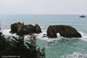
- *Arch Rock (Mile 344.8) – they have bathrooms
- Spruce Island (Mile 345.0)
- *Thunder Rock Cove (Mile 345.8)
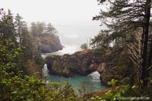
- *Natural Bridges (Mile 346.0)
- North Island (Mile 347.4)
- Thomas Creek Bridge (Mile 347.8)
- Indian Sands (Mile 348.6)
- Whaleshead Viewpoint (Mile 349.3)
- House Rock Viewpoint (Mile 351.2)
- Cape Ferrelo Viewpoint (Mile 351.9)
- Lone Ranch Picnic Area (Mile 352.6)
Recommended Hikes
If you have a bit more time, it’s worth hitting the trails! You can get better views of the coasts and find secret and secluded spots.
Arch Rock Point & Spruce Island Viewpoints Trail
22040-, 22064 Oregon Coast Hwy, Brookings, OR 97415, map
Distance: 0.2 mile loop
Elevation Change: 29 ft
Difficulty: Easy
This is one of the more iconic spots in Samuel H. Boardman. The short loop trail takes you to a few overlooks and a small window amongst the trees to gaze upon Arch Rock below.
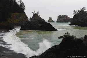
Secret Beach
Distance: 0.2 mile
Elevation Change: 364 ft
Difficulty: Easy
This is definitely worth the stop! There is a way to get here via Thunder Rock Cove, but if you pull out .6 miles south of Arch Rock Picnic Area, there is a small area to park behind the guard rail and a trail that takes you straight the beach. It’s the third pullout going south after Arch Rock.
Natural Bridges to North Island Viewpoint (China Beach) Trail
Distance: 0.5 mile
Elevation Change: 160 ft
Difficulty: Easy
A short walk from the parking lot will take you to one of the best viewpoints in the park as you gaze upon Natural Bridges. Continue on towards China Beach to find a sandy beach.
![]()
Thank you, George. Well done and potentially useful.